Reports from the Knowledge Labs about our recent findings, research topics, and interviews with lifestyle leaders who are creating their own futures.
|
|
| |
How to stimulate your own powers of foresight. Consider the following thought provokers. Ask yourself, in these categories what are the brand new trends and forces? Which are the ones growing in importance? Which current forces are loosing their steam? Which have peaked or are reversing themselves? Which are the "wildcards" about to disrupt us in the future? POLITICAL AND TECHNICAL thought for food: Electronics, Materials, Energy, Fossil, Nuclear, Alternative, Other, Manufacturing (techniques), Agriculture, Machinery and Equipment, Distribution, Transportation (Urban, Mass, Personal, Surface, Sea, Subsurface, Space), Communication (Printed, Spoken, Interactive, Media), Computers (Information, Knowledge, Storage & Retrieval, Design, Network Resources), Post-Cold War, Third World, Conflict (Local, Regional, Global), Arms Limitation, Undeclared Wars, Terrorism, Nuclear Proliferation, Weapons of Mass Destruction, Governments (More/Less Power and Larger or Smaller Scale), Taxes, Isms: Nationalism, Regionalism, Protectionism, Populism, Cartels, Multinational Corporations, Balance of Trade, Third Party Payments, Regulations (OSHA, etc.) Environmental Impact, U.S. Prestige Abroad. SOCIAL AND ECONOMIC Food for thought:
Labor Movements, Unemployment / Employment Cycles, Recession, Employment Patterns, Work Hours / Schedules, Fringe Benefits, Management Approaches, Accounting Policies, Productivity, Energy Costs, Balance of Payments, Inflation, Taxes, Rates of Real Growth, Distribution of Wealth, Capital Availability and Costs, Reliability of Forecasts, Raw Materials, Availability and Costs, Global versus National Economy, Market versus Planned Economies, Generations: Y, X, Boomers, Elderly, Urban vs. Rural Lifestyles, Affluent vs. Poor, Neighborhoods and Communities, Planned or Organic Growth.
Got Knowledge?
|
|
| |
|
|
|
|
The Journal of 2020 Foresight
|
|
| |
|
Thursday, April 28, 2005
Retracing Jedediah Smith's Trail: Bishop, the Mojave Desert and Laughlin
Chapter Three: The Outpost
By Steve Howard, CKO
The Knowledge Labs
Table of Contents
Chapter One: Basecamp
Chapter Two: The Ridge
Chapter Three: The Outpost
Chapter Four: The Tribal Territories
“Indeed, Thomas Jefferson himself spoke frankly of what we would today call genocide. 'We must leave it to yourself to decide [whether] the end proposed should be their extermination, or their removal,' Jefferson once wrote to Clark's older brother, the storied Indian fighter George Rogers Clark. 'The same world would scarcely do for them and us.'"
Jonathan Kirsch
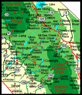
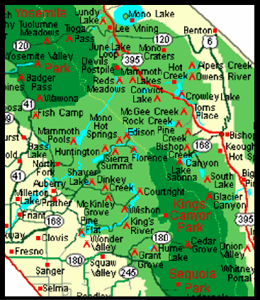
LAUGHLIN, Nevada. Think Jedediah Smith with pedal-to-the-medal passing through at 85 miles per hour. Or Mark Twain in a luxury SUV - Stagecoach Urban Vehicle - accelerating out of Rock Creek headed for Bishop on 395 through the Owens Valley with the snow-capped Sierra mountains on his right and the alkaline flats on his left.
Journal of 2020 Foresight: I can't imagine how grueling a trip like this might have been for the early explorers in the region. In no time we passed from Mono County into Inyo County with only food, fuel or bio breaks in Bishop, Independence, Lone Pine and Big Pine - and it's been grueling on us.
Lone Eagle: Yeah, but on my next trip through here, I want to spend a little more time in Independence. That Winnedumah Bed & Breakfast looked inviting.
Lost Explorer: Ditto. I feel guilty that we didn't have time to explore Mt. Whitney or soak in the significance of the relocation camp at Manzanar.
Pathfinder: We didn't even take advantage of the Yosemite or Rock Creek locations by hiking the John Muir Trail - shame on us. He left a monumental legacy for the rest of us.
Trailblazer: Since you all anointed me the “indicator guru,” and you know I'm fascinated with both the geologic history of the Long Valley Caldera and recent earthquake readings, it is only fitting that I'd want to have spent more time in Lone Pine at the site of the 1872 Earthquake.
J2020F: Well given that Explorer was none too thrilled about how difficult the search for geo cache N 37° 33.738 W 118° 40.838 proved to be, we're lucky we didn't have to separate you two in the SUV like we used to do with our kids!
Eagle: And given that we had to start with that dense geo cache map of California before we could match the photo with the cache location as we got closer - it wasn't easy.
Trailblazer: So, all's well that ends well, right? Especially since we found Little Lakes Valley.
Explorer: True. And, Bishop's history reads like a who's who of the pioneers we profiled since leaving Sacramento. It began nearly3000 years ago with Paiute and Shoshone ancestors - and continued through the early 1800s with visits by Jedediah Smith and Joseph Walker. Later John C. Fremont with Kit Carson, Ed Kern (Kern County) and Richard Owens explored the region. Bishop, itself was named after Samuel A. Bishop.
Pathfinder: Bishop supplied the beef to the more notorious mining camps in Aurora with cattle drives.
J2020F: The one thing we all can agree on, we wouldn't stop at Red Mountain, although we passed right through it and it you see evidence of the boom and bust of mining operations into the 1900s.
Eagle: True. And, you know when we purchased gas at the present day Paiute casino in Bishop, I thought they can't be too happy about the camp or Fort Independence historical marker signifying the Bishop Creek battle.
J2020F: Talking about Jedediah on speed - it's really difficult to appreciate the daily hardships the man - and his exploration parties - suffered as he roamed the Great Basin across what was known as the Great American Desert to later wagon trains and emigrants venturing into the unknown.
Pathfinder: Right. Just think about it. He was the first American to enter California overland from the east across the forbidden Mojave Desert.
Trailblazer: I know. I couldn't help marvel at what he accomplished, especially after we drove past Death Valley and Mojave to get to Needles for the last leg of our journey to Laughlin.
Explorer: Didn't he take our same route, but from the opposite direction - starting on the Colorado River, traveling south and then west?
Pathfinder: The way I remember it, he headed towards the villages of Mojave Indians, then turned his band westward across the Mojave Desert. Kind of threading the needle between hostile Native Americans and Mexican authorities mistrustful of his fur trading deals.
J2020F: If you look at this 1895 map you get a somewhat historical snapshot of what it must have been like. By the way, is it Mojave or Mohave? Must be a state thing that switches from California / Nevada into Arizona?
Eagle: Speaking of needles he came under attack while crossing the Colorado River in what is now Needles, California. A party of Mojave Indians, angry with an earlier trapping party, killed ten of Smith's men and scattered his furs and supplies.
J2020F: You know what is hard for me to get? The attraction to this area - and yet it is on both of the lists - the Nevada resort appreciation and the early growth towns like Elko, Carson, and Jackpot.
Pathfinder: And, both Bullhead City in Arizon. and Laughlin across the Colorado River in Nevada grew recently to dwarf nearby Needles.
Trailblazer: Especially after arriving at the Flamingo Hotel earlier than we had expected in that kind of dry heat you experience if you've ever opened a pizza oven door and were hit by the blast of heat.
Explorer: Well, guys. It's not too different than Las Vegas. Laughlin is sandwiched between deserts - but it borders the Colorado River as the river continues its journey to the Gulf of California (the Sea of Cortez).
Eagle: And remember, nobody in our expedition had rented wave-runners before, nor had been to Laughlin, so we fumbled a little getting into our room, deciding on what to do, what to take with us and where to go.
Pathfinder: Yeah, but after a little conversation with the local guides, we were pointed to the Riverside Hotel where they ferry you across the Colorado to the rental place.
J2020F: But, what we didn't realize was how hot it was on the rocks and dirt. Not a beach for tourists. We really could have used our water walking shoes -- and frequently applied sunscreen.
Explorer: And we had a ball cruising up and down the river, from the dam at one end to the last of the strip hotels - Hurrahs - on the other. The Colorado River cooled us, even though we'd feel heat currents from either the desert or the engine.
Eagle: That was fun all right, but I thought it became hilarious when we tried to outdo each other in outlandish answers to how did the town get its name.
Pathfinder: It wasn't until we got back to the hotel that we were able to Google and find the real answer to “Laughlin” - in the form of a jeopardy question, “So who is Don Laughlin?” And what's his connection with Jedediah Smith?
Got Knowledge?
Copyright ©2002 - 2006 Aarnaes Howard Associates. All rights reserved worldwide.
6:07 AM
Monday, April 25, 2005
The Confluence of Eves Dropping, Geo-caching, and Zip Coding in the Volcano
Chapter Three: The Outpost
By Steve Howard, CKO
The Knowledge Labs
Table of Contents
Chapter One: Basecamp
Chapter Two: The Ridge
Chapter Three: The Outpost
Chapter Four: The Tribal Territories
“Among the earliest entries in the journals that Clark kept is an account of a firefight with a party of Indians that left four men and four ‘squaws’ dead, and ‘2 children 16 horses and 100£ worth of plund'r’ in the hands of the frontiersmen. ‘There was no room for Indians in Jefferson's empire of liberty,’ writes Jones.”
Jonathan Kirsch
MAMMOTH CONSOLIDATED MINE, California. Yet another delay, but one well worth it. Trailblazer introduced us to a hobby none of us ever heard of before. We just had to check it out before hightailing it out of town on California Highway 395.
Journal of 2020 Foresight: Geocaching? I remember seeing Cache La Poudre River, north of Denver on the Overland Trail Map and recalling descriptions of fur traders who buried their furs and supplies for later use. Is that it? Where are we going? We’re not in Colorado, yet.
Trailblazer: You’re close. Where are we going? N 37° 35.701 W 118° 59.314, That’s where.
Pathfinder: Look, here I found it. Here’s the definition of geocaching.
Explorer: So it’s like a GPS backpacking geek’s idea of a good time – kind of a scavenger hunt?
Eagle: Instead of furs or supplies, the first geocache explorer marks the site with a container of interesting or unique-to-the-area items. And the other adventurers discover what’s there and login, right?
Trailblazer: Right, and now they record their journals on the web. Take this one, for instance: “From this Cache Site you are rewarded with an incredible view of Lake Mary, Mammoth Mountain and Mammoth Crest and just below the Cache Site you can see 2 of the remaining mine shafts of the Mammoth Consolidated Gold Mine.”
J2020F: So other than for the “indicator” similarities, how did you get hooked on geocaching.
Trailblazer: Actually I overheard someone talking about it a couple of tables away one morning when I was eating breakfast at The Stove. At first I thought they were talking about the zip codes and lifestyle clusters the California Expedition used to screen potential real estate investment, but I didn’t recognize any of the team members.
Eagle: Let’s see. From the original list we’ve got in the innovation appreciation stage just one -- Pescadero -- 94060. At the early growth stage we’ve got four: Oakhurst -- 93644, North Fork -- 93643, Healdsburg -- 95448 and Yreka -- 96097.
Explorer: What about on the mid-growth or late growth and early maturity appreciation lists?
Eagle: Nope. Three for mid-growth: Sonoma --95476, Mendocino -- 95460 and Morro Bay -- 93442, 92443. And, for late-growth … nope. Just four: Del Mar -- 92014, St. Helena -- 94574, Calistoga -- 94515 and South Lake Tahoe -- 96150. No Mammoth. Maybe on a California Mountain Resort list that would include Mammoth -- 93546, Running Springs -- 92382, Lake Arrowhead --92352 or Big Bear --92315
J2020F: So nothing by zip code – lifestyle indicators?
Trailblazer: Right, I knew it didn’t add up. Back then I knew Mammoth didn’t make the cut, although today it might be high on their list.
Eagle: I agree. Especially with the recent news that Dave McCoy’s remaining interest is up for sale.
Trailblazer: And, I knew Mono Lake wasn’t even close to making their list, so I jotted down the name Shaun somebody and the term Confluences and Googled them when I got back to my room.
Pathfinder: Curiosity got the better of you. What did you find?
Trailblazer: Confluences meant Degrees of Confluence and Shaun Fleming visited two countries and logged in 74 visits, complete with photos as part of the Degrees of Confluence Project. From Shaun’s web page I browsed the US tally, drilled down to the California sites and photos, and then zeroed in on Toulumne and Mono Lake -- and that last one brought me full circle to Shaun – and to these Sierras.
Pathfinder: I can see why you keep coming back to The Sierras. This whole area is magnificent. I can see how it’s hard to run out of things to do or to explore.
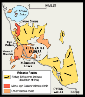
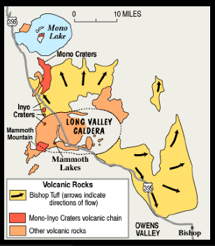
Trailblazer: And, look at these photos, courtesy of the Long Valley Observatory run by the U.S. Geological Survey Volcano Hazards Program to You can see the Caldera outline off in the distance.
Pathfinder: Volcano Hazards? Caldera?
J2020F: It’s hard to see here, but as we leave town and make our way down 395 we’ll see the ancient bronze and black lava flows. And then, we’ll head East through the lower tip of Nevada into Arizona.
Pathfinder: Lava flows?
Trailblazer: Here. Look at this map of Long Valley, and the photo gallery courtesy of “my friends” over at the Volcano Hazards Program.
Eagle: Is it me or is this a little bizarre? We’re flying down US highway 395 doing what, 73 miles an hour, in the middle of a Volcano Caldera? To our right out of the passenger’s side of the SUV we can see the massive jagged peaks of the Sierra Nevada.
Explorer: Yeah, it kind of shatters my mental images of volcanoes spewing lava in some remote site on an island somewhere.
Pathfinder: And, it’s mile after mile of those grey granite peaks with pockets of dark shadows from fractal clouds highlighting erosive cracks and boulders.
Trailblazer: You are right. This two-lane highway crisscrosses the crater of the ancient volcano. The further we continue down the valley and drive across the high desert, the more we’ll see gentle hills of iron color and piles of black frozen molten rock -strewn on our left and on our right.
J2020F: I have to admit it, that as much as I’ve complained about delays, I’m not quite ready to leave this area.
Trailblazer: Great segue. Should we break news to him? Don’t worry; you’ve got more time.
J2020F: What do you mean?
Pathfinder: We negotiated for more time on the back end of this journey.
Eagle: And that means we’re going in search of ….
J2020F: In search of?
Explorer: In search of -- N 37° 33.738 W 118° 40.838.
Trailblazer: Just a slight detour, not too far out of our way.
Pathfinder: Don’t worry; we’ll still visit Bishop, Big Pine, Independence, Lone Pine, and my personal favorite, Red Mountain.
Trailblazer: But, first a little side trip. Hold it, I think we turn up here about 500 yards at Tom’s Place and Rock Creek. We’ll set up a little basecamp and then check out a few caches.
Explorer: Think of it as our attempt to extend the Information highway into the wilderness here along roaring Rock Creek.
J2020F: I had little choice, since Pathfinder drove. And I must say I fell in love with the creek’s ice-cold turbulence slamming and cutting its way through boulders and fallen ancient logs as it has for eons. It provided the background symphony that made falling asleep early very easy. And it served as an early morning alarm at the crack of dawn.
Eagle: Morning. Did you notice how the source of the creek seems to surge down those granite-faced cliffs?
Pathfinder: Good morning. I picked up two of the three John Muir Wilderness area maps. So, I’m guessing we’re talking about the creek cascading down from Mt. Julius Caesar (13196 feet). Down from Mt. Dade and Abbott (13,704 feet). Down from Mt. Morgan and Morgan Pass (11104).
J2020F: Pretty impressive altitudes. Where are the others?
Eagle: They’re already into their early morning routines.
J2020F: Mine were realizing that for this cold, chilled Rock Canyon air, I’d need something warm to make it from my tent tour central meeting place. The first few things that crossed my mind were: Gather twigs for the fire. Get the water boiling for coffee. Wash the sleep out of my eyes.
Pathfinder: Yeah, a completely different internal monologue than the one I’m accustomed to back home. Mine continued with several: Where did we pack the ... (fill in the blanks)?
J2020F: Listen to that. Have you noticed how the constant roar, like a busy freeway, fills all the holes in our morning conversation?
Eagle: And I’ve notice a few mosquitoes floating lazily, waiting for their morning meal.
Explorer: We’re back. Just in time for more coffee and the day’s logistics.
Trailblazer: We’ve been monitoring the fast changing, chaotic weather patterns.
Explorer: And how on maps how a few lines on paper don’t necessarily translate into straight-forward trails.
Trailblazer: But, they’ve got the complete information about the elevations on a variety of trails throughout the Sierras, complete with tips, a legend, and icons for trail information.
Explorer: Yeah, but they don’t show the rocks and uneven terrain in the paths.
Pathfinder: Sounds like someone got up on the wrong side of the bed.
Explorer: You would to if he took you through a sea of sagebrush and you complemented that with a swarm of mosquitoes adding itchy areas to the scratches on your legs.
J2020F: As my wife’s Norwegian first cousin told me about surviving in harsh weather – “There is no such thing as bad weather (or terrain in this case), only bad clothes." Let’s get a move on. We’ve got miles to go before we sleep – Bishop, Independence, the Mojave Desert, Laughlin and the Grand Canyon!
Got Knowledge?
Copyright ©2002 - 2006 Aarnaes Howard Associates. All rights reserved worldwide.
6:23 AM
|
|
| |
|
|
|