Reports from the Knowledge Labs about our recent findings, research topics, and interviews with lifestyle leaders who are creating their own futures.
|
|
| |
How to stimulate your own powers of foresight. Consider the following thought provokers. Ask yourself, in these categories what are the brand new trends and forces? Which are the ones growing in importance? Which current forces are loosing their steam? Which have peaked or are reversing themselves? Which are the "wildcards" about to disrupt us in the future? POLITICAL AND TECHNICAL thought for food: Electronics, Materials, Energy, Fossil, Nuclear, Alternative, Other, Manufacturing (techniques), Agriculture, Machinery and Equipment, Distribution, Transportation (Urban, Mass, Personal, Surface, Sea, Subsurface, Space), Communication (Printed, Spoken, Interactive, Media), Computers (Information, Knowledge, Storage & Retrieval, Design, Network Resources), Post-Cold War, Third World, Conflict (Local, Regional, Global), Arms Limitation, Undeclared Wars, Terrorism, Nuclear Proliferation, Weapons of Mass Destruction, Governments (More/Less Power and Larger or Smaller Scale), Taxes, Isms: Nationalism, Regionalism, Protectionism, Populism, Cartels, Multinational Corporations, Balance of Trade, Third Party Payments, Regulations (OSHA, etc.) Environmental Impact, U.S. Prestige Abroad. SOCIAL AND ECONOMIC Food for thought:
Labor Movements, Unemployment / Employment Cycles, Recession, Employment Patterns, Work Hours / Schedules, Fringe Benefits, Management Approaches, Accounting Policies, Productivity, Energy Costs, Balance of Payments, Inflation, Taxes, Rates of Real Growth, Distribution of Wealth, Capital Availability and Costs, Reliability of Forecasts, Raw Materials, Availability and Costs, Global versus National Economy, Market versus Planned Economies, Generations: Y, X, Boomers, Elderly, Urban vs. Rural Lifestyles, Affluent vs. Poor, Neighborhoods and Communities, Planned or Organic Growth.
Got Knowledge?
|
|
| |
|
|
|
|
The Journal of 2020 Foresight
|
|
| |
|
Tuesday, May 31, 2005

Purgatory, The River of Lost Souls, and the Stony Point Trail
Chapter Three: The Outpost
By Steve Howard, CKO
The Knowledge Labs
Table of Contents
Chapter One: Basecamp
Chapter Two: The Ridge
Chapter Three: The Outpost
Chapter Four: The Tribal Territories
“Clark was famously accompanied on the Voyage of Discovery by York, who was regarded as "the bravest of the party" by the Native Americans whom they encountered along the way. After their return to civilization, however, Clark complained that York was "insolent and Sulky" - "I gave him a Severe trouncing," he wrote, threatening to sell him off, although he confided to his journal that "I cant sell negrows here for money."
Jonathan Kirsch
DURANGO, Colorado. Driving us mad. How much of this can anyone take? We spent about an hour exploring Mesa Verde, before we headed to Durango for the last hour of driving that day in search of Grey Owl's third geocache at: N 37° 37.697 W 107° 49.435. We drove out of Montezuma County in the Southwest Corner of Colorado and headed for the general vicinities of La Plata, San Juan and Archueleta Counties along the southern border. With a population that grew from 12,500 to almost 14,000 people over the last few years, Durango sits on the edge of a great desert mesa and enjoys warm breezes and cool lush mountain forests.
Journal of 2020 Foresight: While eating an early dinner at Farquarhts it's easy to see how the downtown gets most of its charm from the classic 19th century hotels and its Victorian architecture, saloons and hitching posts.
Explorer: So much of the West owes its expansion to the railroad, and I guess Durango is no exception.
Pathfinder: I love the story our waiter told about Durango being founded when another community across the Animus River turned down the offer to bring the railroad that would link the mines to Denver.
Trailblazer: I know. It's kind of an accidental incident that turns into a major opportunity - or blunder depending upon your point of view.
Pathfinder: Either way, while Durango was founded by the Denver and Rio Grand Railroad in 1879, it wasn't until August 5, 1881 that the railroad came to the mining and smeltering center
J2020F: Those were heady day in this area -- the heydays of the gold and silver booms.
Eagle: I love the names. “Purgatory”, “River of Lost Souls”, “Silverton.” They all conjure up images of a gold rush town, you know?
Pathfinder: Sure. For instance, sometime in 1776 or 1777Father Escalante named the Animas River (River of Lost Souls) on his way to California from Santa Fe.
J2020F: I remember seeing many “Escalante” on the maps throughout the southwest.
Pathfinder: Right. Father Silvestre Velez de Escalante's party traveled north through western Colorado, until they became lost. They would have died of thirst had they not met a Ute Indian, who saved them by showing them the way to the Uncompahgre River.
Eagle: It's ironic since one of the reasons the Escalante expedition chose the trail they took was because the Hopi wouldn't tolerate their religion, while the Apaches in the Gila River region posed a physical threat to their safety.
Explorer: Where did the name Colorado come from?
Pathfinder: The story I heard was when the Spanish conquistadores explored the state for riches, but instead they found a spectacular reddish-brown landscape they described as colorado - or color red.
J2020F: So, Colorado didn't become part of the American Territories until after the Mexican-American War, like Arizona and New Mexico?
Pathfinder: Partially right. In the Louisiana Purchase of 1803, the United States bought most of the Colorado territory at the cost of 4 cents per acre - the land east of the Rockies.
Explorer: I noticed that Zebulon Pike in 1806, explored the territory while Lewis and Clark made their way to the Pacific Coast at the Columbia River, explored Colorado.
Pathfinder: Instead of the Northwest Passage, Zeb Pike received the assignment to find the headwaters of the Red and Arkansas Rivers, so his expedition explored the southern territory of the Louisiana Purchase for two years.
J2020F: You know, I've got this feeling - there's another coincidence you're about to describe. Am I right?
Pathfinder: You mean the connection to what we discovered about the area in which your family put down roots on the Gasconade and Missouri Rivers?
J2020F: What, he's my long lost great, great, great uncle Zeb?
Pathfinder: Not exactly.
J2020F: What then?
Pathfinder: Remember reading Brackenridge's Journal entry about meeting the militia commander in 1811 who lived on the Gasconade River near Osage County?
J2020F: He told the story how they had been chasing down Potawatomi raiders the night before. And I was recalling how the arrowheads and one tomahawk I found might have been from Osage or Potawatomi tribes.
Pathfinder: Exactly. That's the coincidence. One purpose for Pike's expedition was to return to their native soil of 50 Osage Nationprisoners who had been held hostage by rival Potawatomis and liberated by the US Army.
Explorer: So that's it?
Pathfinder: No. That was an overt mission. The covert mission had to do with boundaries of the purchase.
Explorer: With the French?
Pathfinder: No, the problem was with the Spanish. Pike's secret mission was to figure out how well the Spanish could defend their claims if push came to shove in the Kansas, Colorado, New Mexico and Texas general areas.
J2020F: When gold was discovered in the mountains of Colorado, new hordes of prospectors swarmed across the Great Plains that Pike largely discovered.
Eagle: Two vast new territories were organized, Kansas and Nebraska, encompassing virtually all of the country of the Plains tribes.
Trailblazer: And it's not known as Purgatory any more.
Pathfinder: What?
Trailblazer: The colorful names. You asked about the River of Lost Souls and the ski resort is no longer Purgatory.
Pathfinder: You mean we can't officially tell people to go to hell for the best local skiing in these here parts.
Trailblazer: Now it is the Durango Mountain Resort.
J2020F: But, you can check out the mountain and town by web cams around the clock.
Trailblazer: Durango sits in the shadows of the San Juan Mountains, geographically younger than other Colorado mountain ranges. they haven't weathered as much, so they appear more jagged and captivating, at an elevation of 6,500 feet above sea level.
Explorer: As we drive through these mountain roads you can't help but notice the brown, red, yellow tracings from mine shafts long ago abandoned. But, I was done with driving by the time we found our hotel.
Pathfinder: I'm with you especially after being so close, at Mesa Verde, yet so far.
J2020F: And finding the Best Western Rio Grand took awhile, especially when the address listed looked to be at the wrong end of a one-way street, a problem we eventually solved.
Trailblazer: C'mon guys. The location couldn't have been better for our “Corps of Re-Discovery”right behind the Silverton Durango the Durango train depot and roundhouse -- and the hub of the city.
Eagle: We jumped into the indoor pool before and briefly, and for the first time on our trip, unanimously agreed on the first adventure of the next day.
Trailblazer: I just wanted to go to bed.
J2020F: Some might say you got up on the wrong side of the bed the next morning when you read my lips: “Stand-by?”
Trailblazer: Well, we were shocked. Grey Owl tipped us off before the trip, Take the Silverton narrow gauge one-way, but not up and back. Try a bus, or maybe a jeep tour. But the train is so sllllooooooowwwww.
Eagle: I'm with Trailblazer. Up early from the hotel, waiting in line for the bus. Missing the earliest.
Explorer: And, it's not like we've got a precious vacation day to waste standing in line. We grumbled for a while trying to figure out how to kill about an hour and come back stand-by for the next bus.
J2020F: Here we thought it would cut into the time to explore Silverton. But as it turns out, after schmoozing with the driver we boarded and made it up for the delay the winding Durango to Silverton road with his local insights.
Trailblazer: We caught the 11:45, and still had plenty of discovery time.
Pathfinder: I guess we lucked out, when the driver announced: "Unlike the other guides who came to Durango from Florida or Minnesota, I'm an original -- born and raised in Durango. I know every mountain, river, lake, tree, plant and all the local history -- so sit back and sleep if you want, but I'll make the hour trip as entertaining as I can. Just ask away -- any questions."
Explorer: I thought we'd have to muzzle Trailblazer after that opening, but I guess you didn't feel like being a wise guy.
Pathfinder: Okay, so it was a canned presentation, but he told us he drove the summer bus runs and worked at Ski Resort-formerly-known-as- Purgatory during the winter season.
J2020F: Well, here's what I picked up. Construction began on the narrow gauge railroad line in 1881 between Durango and Silverton. Nearly a year later it was completed and began hauling mine ores -- over $300 million -- throughout the years.
Pathfinder: For roughly eighty years. Durango became cut off from the rest of the Denver and Rio Grande Western Railroad in the late 1960s, isolating the remaining narrow gauge track along the 45 mile route between to two towns.
Trailblazer. So, today for us tourists, the locomotives operate 100% on coal-fired steam and were manufactured by the American Locomotive Works in 1923 or Baldwin Locomotive Works in 1925. All the coaches are from the 1880s era -- many originally build in the 1800s.
Explorer: The trip hugs the walls of the Animas River Canyon, rises to 11,000 feet and takes you back to the Silverton frontier days through forests, history, and natural wonder.
J2020F: We endured the Colorado afternoon rain. We lunched, walked the main street, and visited Blair Streets once booming bordello district.
Pathfinder: I guess you could say we did what every other tourist did. We window-shopped, snapped pictures of a street that looked like it could have been the backdrop for the “Gunfight-at-the-O.K.-Corral.”
Trailblazer: The bus driver told us Silverton had 300 inches of snow each year and because of avalanche danger nothing was built on the other side of the river.
Eagle: I loved his line - “But, kids, there aren't any snow days, because everyone walks to the one room school which could fit in this bus."
Explorer: “Look up on the hill,” he said. There protecting the mining town was a monstrous statue, Christ of the Mines Shrine, built in 1958 -1959 as a tribute to all those who worked the mines. "One Sunday, the only time the mines around here weren't working, a nearby lake broke through the ground and flooded the mines. No fatalities, but if it had been on any other day of the week, at least 150 god-fearing souls would have been lost."
J2020F: He also said only the hardy stick around in the winter. “Now in the summer there are about 1500 people living here with 2 grocery stores, two gas stations and 4 saloons. In the winter about 400 people, 1 grocery store, 1 gas station and 4 saloons.”
Pathfinder: He also told us that Silverton sits in a small valley called Baker's Park, named after Charles Baker who led a small expedition to the area around 1860. After the Civil War miners began flooding into the area, when it was still Ute Indian Territory -- originally their hunting grounds.
Explorer: And here's another coincidence for you. It has something to do with the only way in to the area at that time - Stony Pass Trail.
Pathfinder: That's right. A member of Baker's original party of prospectors - George Howard, founded a town named after himself.
J2020F: I'll be.
Explorer: Turns out he was quite an entrepreneur.
Pathfinder: Here's how the story is told: “When George decided he needed to build a log cabin, he put the free enterprise system to work. George hauled in a large stack of logs and set a barrel of whiskey next to it.”
Explorer: “As the thirsty miners came into the area over the Stony Pass Trail, George would offer them some refreshment. When the miners began to feel the effects of the free refreshments, George would ask them for a little help on his cabin.”
Pathfinder: Before long he was the owner of the first permanent settlement in Howardsville.
Eagle: According to Dee Brown: "The Ute's were Rocky Mountain Indians, and for a generation they had watched the invading white men move into their Colorado country like endless swarms of grasshoppers.”
J2020F: Did they realize what was to become of them right away?
Got Knowledge?
Copyright ©2002 - 2006 Aarnaes Howard Associates. All rights reserved worldwide.
7:21 AM
Monday, May 30, 2005
Journeys of the Heart, Mesa Verde Collapse and New Mexico Expeditions
Chapter Three: The Outpost
By Steve Howard, CKO
The Knowledge Labs
Table of Contents
Chapter One: Basecamp
Chapter Two: The Ridge
Chapter Three: The Outpost
Chapter Four: The Tribal Territories
“More chilling is a note from Billy's (William Clark's) father, a few months before the signing of the Declaration of Independence, serving as a safe-conduct pass to permit a house slave called Cupid to attend church services. Clark himself was a slave owner, as Jones points out. One of Clark's journal entries recorded the deaths of "Nan[c]y's Child, and Bens horse," thus "pairing the loss of a slave child and a domestic animal in a single sentence." And he boasted that his cook had become "a very good wench since she had about fifty" - 50 lashes of the whip, that is. "Indeed, I have been obliged [to] whip almost all my people. And they are now beginning to think that it best to do better and not Cry hard when I am compelled to use the whip." This is a very different figure from the man we met in Stephen Ambrose's "Undaunted Courage."
Jonathan Kirsch
CORTEZ, Colorado. While in the area we took a little side trip looking for Grey Owl's second geo-cache-- N 36° 59.614 W 109° 02.460. Turns out, it took us to a pretty desolate area, complete with rattle snake warnings along a dirt road nearShiprock, New Mexico. On the map we found ourselves in a triangle in the northeast corner of the state, but still on Navajo Reservation land.
J2020F: Are we there yet? Is that it? What did you find?
Trailblazer: It's very similar to the contents in Grey Owl's first geo-cache. A note, but this time it's a list of locations taken from the New Mexico Expedition. It listed:
Three innovation towns in New Mexico. The first is Silver City -- 88022, 36, 53, 61,62 (in Grant County, promoted as the Gateway to Gila National Forest & Wilderness, with news from both the Silver City Daily Press and the Silver City Sun-News
The second is Angel Fire - 87710 (and a link to itsChamber of Commerce, and Sangre de Cristo Chronicle).
And, the third: Red River - 87558 and you can read all about it in the same Sangre de Cristo Chronicle like Angel Fire - both resort towns make up part of the “Enchanted Circle of Northern New Mexico” - a 90-mile route in Southern Rockies including Taos, Angel Fire and Eagle Nest - Cimarron.
The first of two early growth resorts isRuidoso -- 88345, 55 (Ruidoso News)
The second is Las Cruces --88001, 02, 03, 05, 11, 12 (in Dona Ana County, as covered by the Las Cruces Sun-News, including their homefinder).
Next on the list is only one mid-growth: Taos - 87571 (with up to the minute stories found in The Taos News)
And, finally one late growth - early maturity community: Famous Santa Fe -- 87501,02, 04, 05, 06, 40, 94 (with three sources for news articles: Santa Fe New Mexican, Santa Fe Reporter, and the Santa Fe Times).
Eagle: As much as I want to visit all of them, I don't see how we can. I say we continue through Colorado, as originally planned.
Explorer: I'm with you. We've already made plans to hook up with Finnmark at Grey Owl's suggestion. It's just a matter of how much we want to cover between now and then.
J2020F: Stopping briefly at the Colorado Welcome Centerin the Cortez City Park, we realize that we're at another major crossroads. Northwest on 555 takes us past the Crow Canyon Archeological Center to Dove Creek and the DoloresRiver Overlook. West is the Ute Mountain Ute Reservation. South is where we've been on 160. Northeast on 145 takes us to Telluride through the San Juan National Forest. East takes us past Mesa Verde National Park, on 160 towards Durango. We decide to stick to U.S. 160 headed east.
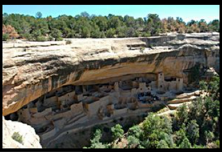
Explorer: Bummer. We're twenty minutes away from the first set of Mesa Verde ruins and the ranger told us they close in an hour. We lost an hour during the time change - something we hadn't counted on. And, that put us into the park entrance later than we wanted.
Pathfinder: That means that the Balcony House and the Cliff Palacetours would be closed.
Trailblazer: Where did we mess up? We plotted our route taking us near Mexican Hat to the 666 and towards Cortez,
Explorer: I didn't even consider a time change for Mesa Verde and Durango.
Eagle: This has been one trip with a lot of driving. All I had thought about is next stop the Mesa Verde and than 45 minute drive to Durango, our outpost for three nights and two days before pressing on to Denver.
J2020F: The ranger said to visit the museum and the Spruce House since we could visit without tickets or a guide.
Pathfinder: Not until we hiked down to the Spruce House, did I begin to appreciate the severely shortened stopover. We climbed down into a Kiva and then I forgot about our time constraint.
Explorer: Me, too. It was like I was transported into a different world, a different time. I could begin to use my imagination.
Trailblazer: For me it happened while driving around the scenic loop. There evidence of earlier communities out in the open on the top of the mesa that once flourished wasn't anything that I had expected.
Eagle: I know what you mean. It's as if as warring tribes or other threats challenged their existence, they moved to the cliffs for protection.
J2020F: At least we had enough time to take in cliff dwellings that appeared in the shadows across the canyons from a turnout.
Explorer: We stopped and photographed like so many other tourists before and after us -- until the rain moved in.
Pathfinder: The centuries of inhabiting this area begins to sink in when you stand here next to our SUV with digital cameras in hand and gaze out across the canyon to the complex of early Anasazi cliff homes - what, some 1400 years before the first European explorers laid eyes on the territory - or even stepped on North American shores!
Eagle: Anasazi people -- Ancestral Pueblo-ans -- lived for roughly 700 years in Mesa Verde, having migrated from the Four Corners region.
J2020F: That's three or four times longer than the United States has been in existence.
Explorer: The heart of the Anasazi region spanned northeastern Arizona, northwestern New Mexico, southeastern Utah and southwestern Colorado-a land of forested mountain ranges, stream-dissected mesas, arid grasslands and occasional river bottoms.
Trailblazer: However, in the 12th or 13th century over a period of one or two generations the Anasazi vanished from this mesa. Because they left no written records, their story is incomplete.
Pathfinder: But it is the pueblos of Arizona and western New Mexico and those of the upper Rio Grande drainage that greeted the Spanish expeditions into the Southwest in the 16th century.
Eagle: What began as a small trickle grew into a flood as several million Europeans and their descendents forced their ways upon the indigenous people of the New World over the centuries to come.
Pathfinder: For four centuries, from 1492 - 1890, Europeans convinced the “heathens” they found to adopt their ways.
Explorer: In 1539, for instance, Franciscan Friar, Marcos de Niza, followed by Francisco Vasquez de Coronado's Spanish expedition first came looking for trade routes to the orient and Seven Cities of Gold, as well as to colonize the New World.
J2020F: Disappointment over the lack of physical riches soon was replaced by Spain's legendary missionary zeal.
Eagle: And the Spaniards were sorely tempted by the wealth of the American Indian souls ripe for conversion.
Pathfinder: So, by the end of the 16th century Juan de Onate officially had claimed this area for Spain.
J2020F: It certainly seems clear, that while the Anasazi had abandoned this mesa before the Spaniards came, they had mastered community living -- taking advantage of nature by building their homes under the protection of overhanging cliffs.
Pathfinder: Apparently, analysis of the ruins and excavated artifacts point to a civilization using rectangular shaped sandstone blocks held together with cement made from mud and water.
Explorer: It says here in the official park brochure that their rooms averaged about 42 square feet and housed two or three people. They stored crops in isolated rooms and in the upper levels.
J2020F: Ironically, garbage heaps, from years of tossing over food and broken tools -- knives, axes, awls, stone and bone scrapers, and pottery -- have yielded the most knowledge about the Anasazi.
Explorer: I'd hate to think what story a lifetime of garbage would tell future archeologists about me!
Eagle: Right, we know they farmed beans, corn, and squash crops. They hunted deer, rabbits and squirrels and domesticated turkeys and dogs.
Trailblazer: Before they learned how to make pottery, they had mastered the art of basket making using a spiral twilled technique for hauling water, storing grain and perhaps even for cooking.
Pathfinder: And a thousand years before the Spanish conquistadors and missionaries arrived, around 550 A.D. pottery obsolesced basket weaving. They created pots, bowls, canteens, ladles, jars and mugs.
Eagle: They stored and cooked in them. Rituals and ceremonies incorporated them.
Trailblazer: They managed to produce a surplus of goods that gave them an advantage in a trading economy -- stretching all the way to the Pacific coast, as evidenced by seashells.
Pathfinder: It also says about five hundred years after the first pots appeared -- by 1100 to 1300 - the Anasazi entered the Mesa's classic period.
J2020F: What do you mean by the Mesa's classic period?
Eagle: That is when about several thousand tribal members concentrated in compact villages with many rooms, kivas, and round towers we see today.
Explorer: Most of the cliff swelling were build from 1190 to 1270, ranging in size from one-room house to 200-room villages -- Cliff Palace.
J2020F: Kiva? What is a kiva?
Eagle: The kiva -- a Hopi term -- means ceremonial room.
Pathfinder: These underground chambers were used in much the same way churches were used much later in our country's history. Here they performed healing rites, prayed for rain, luck in hunting or for good crops in the upcoming seasonal harvest.
Trailblazer: They may have been the community center where weavers and potters gathered to practice their craft. A small hole in the floor, called a sipapu, is the symbolic entrance to the underworld.
J2020F: But, they lived in the cliff dwellings for less than 100 years. By 1300 Mesa Verde had become a ghost town. Why?
Trailblazer: Probably due to a draught, scientists theorize. Crops may have failed. Or after literally hundreds of years of intensive land use the soils, the forest and their animals may have become depleted resources.
Eagle: Or maybe the political and social climate made it intolerable for the tribe to remain.
Pathfinder: What remains today are three major cave dwellings on Chapin Mesa. The Spruce Tree House. Cliff Palace. Balcony House. Driving the loops of Ruins Road from canyon rim vantage points can see other dwellings.
J2020F: But whatever the reasons, they traveled south into what is now Arizona and New Mexico becoming reacquainted with relatives already settled there, right?
Eagle: As we already found out in Arizona, some of the Pueblo people and other tribes in the region are direct descendants of the cliff dwelling Anasazi.
Explorer: And we already know that those Pueblo tribes chafed under Spanish occupation, especially in New Mexico - culminating in the 1680 Pueblo Rebellion.
Trailblazer: The reason? Increasing cultural and religious oppression sparked the rebellion. But, the victory over Spanish rule reversed when a force led by Don Diego de Vargas reclaimed the area in 1692.
Pathfinder: But, after a century of isolated occupation, the Spanish Empire in the New World collapses by the1800s.
Explorer: In 1821 the Santa Fe Trail opens to hoards of American settlers.
J2020F: If we made a side trip to Taos, New Mexico we'd find Kit Carson State Park that includes the cemetery where he died, and the Kit Carson Home and Museum where he lived from 1843 to 1868.
Pathfinder: That's right. Carson has shown up in Nevada, Arizona and now New Mexico. In 1846 Stephen Kearney captures Santa Fe during the Mexican War.
J2020F: I recently discovered another coincidence. Twenty years earlier Kearny became the first commander of the new (1826) Jefferson Barracks, in Missouri where my great, great grandfather Nathan died in the Civil War.
Explorer: After protecting emigrants traveling the Oregon Trail from Native American attacks, Kearney moves a force of 1700 to Santa Fe where he becomes military governor. Kit Carson guides Stephen W. Kearny's party from New Mexico to California to fight during the Mexican War.
Pathfinder: Mexico ceded the land at the war's end in 1848, and it officially became a U.S. territory in 1850. On the strength of his war record, General Zachary Taylor became the twelfth U.S. President, serving only form 1849 to 1850.
Trailblazer: Near what is today the Southern Methodist University's research center at Fort Burgwin, the 1st Dragoons of the Calvary lived from 1852 to 1860.
J2020F: Remember, it was the 1853 Gadsden Purchase that brought the rest of the area that is currently Arizona and New Mexico under U.S. control.
Pathfinder: In 1853 Kit Carson was appointed as Indian agent for Taos, New Mexico. But, peace remained elusive, however. In 1862 two key Civil War battles were fought in the fledgling territory. They resulted in southern victories but when the Confederates lost their supply chain they were more easily defeated.
Eagle: The Union Army turned its attention to defeating the Apaches, beginning with the Battle of Apache Pass, for two decades between 1865 and 1886 in Arizona and New Mexico Territories.
Explorer: Eventually as more settlers arrived with the Indians becoming more of a nuisance than a real threat, the violence shifted to the range wars.
Pathfinder: The 1870s brought national peace but local conflict, and in 1878 ranchers, landowners and homesteaders squared off in a vicious fight for economic control of the territory.
J2020F: Wasn't that when the Billy the Kid earned his reputation?
Pathfinder: Little is really known about him - his real name, where he was born, for instance.
J2020F: Didn't I read somewhere that in 1873 his mother married William Antrim and the family moved to Silver City, New Mexico. I believe his stepfather was a bartender and carpenter but soon became more interested in prospecting than his family.
Pathfinder: Yup. Known as the Lincoln County War, the 5-day gunfight is notable mainly for the participation of Billy the Kid.
Explorer: The Kid's exploits -- most of them illegal -- epitomize the Wild West era.
J2020F: How so?
Explorer: Until the early 1900s, so many groups each with their own vested interest squared off against one and another.
Eagle: Taking advantage of the turmoil, various American Indian tribes intensified their own costly but unsuccessful war for freedom, which ended in 1886 with the surrender of Apache chief Geronimo and his followers.
Explorer: The railroad reached the area in the 1880s, bringing with it greater numbers of settlers.
Pathfinder: Mining towns profited as silver, gold, copper, coal and uranium were discovered. The boom was short-lived, however, and many of these cities became ghost towns as the mines closed.
Explorer. Finally, New Mexico was admitted to the Union on January 6, 1912.
J2020F: Before I forget, you said in addition to the New Mexico Learning Expedition's list there was a note?
Trailblazer: Oh yeah, right!
“A personal relationship to the Creator, the Great Spirit, is in Native American cultures not something that must be created. It is something that must be remembered.... Many roads lead to the heart.... Like a roadmap that helps you see the destination, if only from a distance. If you know how to read the roadmap, you can follow the roads into the land that you seek."
The East -- The start of life's journey, the new day, is in the East. Just as it is the place on this continent where the European world first came into contact with the Native people of North America, it is the place of beginnings, first light -- and the possibility of starting again.
The South -- The South holds the warmth of summer. It is a time of innocence, of learning and growth.
The West -- The West reminds us of the wisdom of maturity with the approach of the sunset. It is the time of parenthood, responsibility, and good sense -- the time to teach, acknowledge, and give thanks.
The North -- The North holds that hard, cleansing wisdom of the time of winter and white hair, the elder's breath through the sacred pipe, the grandparents who, on life's great circle, are closest to the little children.
The Sky Above -- "A man may be able to do things in a mysterious way, but none has ever been found who could command the sun and moon or change the seasons. The most wonderful things which a man can do are different from the works of nature. When the seasons changed, we regarded it as a gift from the sun, which is the strongest of all the mysterious Wakan powers ...."
Anonymous Teton Sioux, circa 1918.
Oh, and the next set of coordinates: N 37° 37.697 W 107° 49.435 on 550.
Got Knowledge?
Copyright ©2002 - 2006 Aarnaes Howard Associates. All rights reserved worldwide.
7:05 AM
Friday, May 27, 2005
Four Corners, Seven Directions, But One Wakan Tanka
Chapter Three: The Outpost
By Steve Howard, CKO
The Knowledge Labs
Table of Contents
Chapter One: Basecamp
Chapter Two: The Ridge
Chapter Three: The Outpost
Chapter Four: The Tribal Territories
“Some of the most charming moments come when Clark sits down with Nicholas Biddle, the highborn Philadelphia attorney who would edit his journals. Biddle interrogated Clark on every detail of the expedition: "Did both Indian men and women have the venereal? Are there oysters on the Pacific coast? How do Indian mothers flatten the heads of their babies? Does [Clark's slave] York have a wife?" The touchiest question focused on what Biddle delicately called "the point of rank and command" between Lewis and Clark. "Equal in every point of view," insisted Clark, still bitter that he had been denied the rank of captain that Lewis enjoyed.”
Jonathan Kirsch
FOUR CORNERS, Navajo Nation. “The only good redskin is a ….”
Much of Arizona's history, and of the Four Corners Region in general, revolved around settling the ”Indian Issue” - making the territory carved out of Utah, Colorado and Mexico and New Mexico territories specifically - safe for settlers, merchants, miners, and the industrialist's investments in the railroad. And, for finding Grey Owl's first geo-cache somewhere in Apache County.
Journal of 2020 Foresight: In the mid-1840s, it became an "obvious (or undeniable) fate." Thanks to John O'Sullivan, a wave of propaganda described it as a “divinely-inspired mission to expand itself and its system of government from ocean to ocean and to the western frontier.”
Eagle: It?
J2020F: Manifest Destiny. Four decades after Lewis and Clark's expedition, victory in the Mexican-American War brought a surge in patriotism with the acquisition of new southwestern lands.
Pathfinder: In theory, one aspect of this desire was its principle to bring the ideals of democratic self-government to any peoples capable of it; in practice, however, this often meant excluding Native Americans.
Explorer: Sounds like the other underlying principle was the one practiced in Carson City, Nevada. The need to fund the Union's war effort.
Pathfinder: Right. And, the broad desire to acquire new lands, since land could represent potential income, wealth, self-sufficiency, and freedom.
J2020F: Decades later in Texas, because the Native Americans terrorized the new emigrants and delayed their settlements, Larry McMurty's pioneer family waited patiently to finally realize their dream -- the acquisition of new land as a way of demonstrating they were no longer shiftless drifters. They became landowners.
Trailblazer: They waited until the Apaches were subdued?
J2020F: No. McMurty names Quanah Parker of the Commanches and their allies the Kiowas, who violently objected to the slaughter of the buffalo - and ultimately their way of life.
Pathfinder: Around the same time Kit Carson starved the Navajos into submission in what is now Arizona, and the US Military had to answer the question, now what about the Apaches?
Eagle: Well, it's a familiar story. In 1863 the discovery of gold in Apache territory brought an influx of white settlers and prospectors who fan out into the mineral-laden mountains.
Explorer: And, just as familiar is the boom - bust cycle. New settlements sprang up over night only to become ghost towns when their “mother lodes” ran out.
J2020F: To get a better “feel” for the times you really should see Jeremy Rowe's slide show beginning with Geronimo between 1850 to 1920.
Eagle: Meanwhile Cochise (Chiracahua Apache) attacked white settlements until 1872 when he was forced onto a reservation
Pathfinder: After the death of Cochise in 1874, his oldest son, Taza, became chief of the Chiricahuas, and Taglito (Tom Jeffords) continued as agent on the Apache Pass reservation. At one time Cochise had worked as a woodcutter for the Butterfield Overland stagecoach station in Apache Pass, now Ft. Bowie.
Eagle: But, in a series of events in the mid-1870s the Apaches were moved to Indian Territory at White Mountain in Eastern Arizona under John Clum who replaced Jeffords and encourages a self-government experiment on the reservation.
Pathfinder: Remember, as a way of life the Apaches had only known their 250-year history of war with the Spanish who, some say, taught them the fine art of torture and mutilation. Few of the 6000 Apaches remaining in the 1860s were of one mind. They divided into several bands each with their relative distrust of all whites.
Eagle: And, later as those bands were forced to move from White Mountain to San Carlos reservations the agency corruption added to the distrust, Geronimo assumes leadership when Cochise's son dies and takes 50% of the San Carlos bands with him across the Mexican border.
Pathfinder: Things don't get any better in the 1880s. In the early 1880s, Chiracahua Apache chief Geronimo continued to overrun the settlers and ranchers.
Eagle: But, the railroad, begun in the 1860s, reached the area two decades later in the 1880s, bringing with it greater numbers of settlers.
Explorer: Oh, yeah. As I recall, in March 8, 1881 the second transcontinental railroad was completed linking the Southern Pacific Railroad with the Atchison, Topeka and Santa Fe Railroad at Deming in New Mexico Territory - stirring up even more resistance.
Pathfinder. Over time even the law-abiding reservation Apaches became more susceptible to invitations from the bands on the run to join them in their “war forever against the Mexicans and Americans.” On the reservation only Agent John Clum, though no “noble savage” true believer, “did right by them” and provided a fair and balanced view of territory relations by his example.
Eagle: When General George Crook, a man changed by too many campaigns against the Native Americans, assumes military command of the territory, he launches investigations into reservation corruption and holds out Clum's approach as a standard for returning local control to the reservation Apaches for self-governance.
Pathfinder: Meanwhile, Geronimo remains elusive crossing back and forth across the Mexican border raiding settlers on both sides.
Eagle: Crook realizes nothing will change unless he can craft a cross-border agreement with Mexico and together they can force Geronimo to terminate his raids.
Explorer: Wasn't this roughly the time - between 1878 and 1883 -- when John Fremont governed the newly formed Arizona Territory?
Pathfinder: Yes, indeed - roughly three decades after he held a similar position in California. A couple of years after Fremont left office, in 1883, the railroad reached Arizona bringing prosperity in the form of ranchers, prospectors and farmers.
Eagle: And a new means for quickly deploying troops.
J2020F: What do you mean?
Eagle: In the early weeks of 1883 General Crook moved part of this force down to the tracks of the new Southern Pacific Railroad, which streaked across Arizona to within about fifty miles of the border.
Pathfinder: That's right. With reservation Apaches serving as interpreters Crook and Geronimo meet to resolve the “Indian Issue” peacefully. The talks last for one year and consist of testing each other, building trust and judging each other's integrity.
Eagle: But as in so many agreements before, and since, between the “white father” and the native tribes - one man's agreement is another man's loophole.
J2020F: Why?
Eagle: Think about it. Why did the railroad bring the easterners? Because, gold had been discovered in the Apache territories.
Explorer: I think he's referring to the Tucson Ring and their political clout.
J2020F: The who? What do you mean?
Explorer: You have General Crook's record -- the Indians of Arizona or New Mexico for had committed no atrocities about a year.
Eagle: But, outside the sphere of his influence --the reservation and the Army posts -- Crook fell victim to a media campaign that portrayed him as being too easy on the Apaches.
J2020F: Media campaign?
Eagle: According to Dee Brown, the newspapers had condemned him for disseminating all sorts of exaggerations and falsehoods about the Indians.
J2020F: Who was the Tucson Ring?
Pathfinder: The local group of Arizonan merchants who gained from the influx of troops into the area. The military payroll brought money and profits to the local merchants.
Explorer: They really turned up the heat when Geronimo and his close friends got drunk and decided to go to Mexico.
Trailblazer: Like too many Southern California college students do today, eh?
Eagle: I won't even go there. Some suspected the Tucson Ring for planting rumors that Geronimo was about to be arrested. Others suggest they may have made it easy for him to get drunk - no one really knows today.
Explorer: Rather than face a noose and gallows, Geronimo split.
Eagle: “The Apaches Are Out” read the headlines. Dee Brown writes a trader from the Tucson Ring had filled Geronimo and company full of whiskey and lies about how the white citizens of Arizona would surely hang them if they returned.
Explorer: The Tucson Ring of contractors, seeing a chance for a profitable military campaign, called on General Crook to rush troops to protect defenseless white citizens from murderous Apaches.
Eagle: Geronimo, however, was desperately trying to avoid any confrontation with white citizens; all he wanted to do was speed his people across the border to the old Sierra Madre sanctuary in Mexico.
Pathfinder: What I recall is Crook tried to avoid the vast military operation that the Tucson Ring and their political friends in Washington were demanding of him.
J2020F: Did Crook prevail?
Pathfinder: No, as a result of Geronimo's flight, the War Department severely reprimanded Crook for his negligence, for granting unauthorized surrender terms, and for his tolerant attitude toward Indians.
Trailblazer: So the political machine got what they wanted from Washington?
Explorer: Well, he immediately resigned. Nelson (“Bear Coat”) Miles a brigadier general eager for promotion replaced him in 1886, and got the job done as he had in almost all of the other major Indian campaigns.
J2020F: Other major Indian campaigns?
Explorer: He defeated the Kiowa, Comanche and the Southern Cheyenne; the Lakota Sioux; the Nez Pearce; the Chiricahua Apaches -- and brought the end to the Wild West.
J2020F: How so?
Explorer: He handled the last two significant leaders. He captured and imprisoned Geronimo. He brought to bear the military pressure that, with divine intervention, led to Sitting Bull's death.
Eagle: When Geronimo surrendered for the last time, the Great Father (Grover Cleveland), who believed all the lurid newspaper tales of Geronimo's evil deeds, recommended that he be hanged.
Explorer: Dee Brown says, a counsel of men who knew better prevailed, and Geronimo was sent to Fort Marion, Florida - to join the rest of his tribe.
Eagle: If you've ever spent any time in humid Florida and then imagine contrasting that climate to this dry arid territory, you can foresee the drastic effect forced relocation would extract from the Apaches.
Pathfinder: Didn't Geronimo discover most of his friends dying? I believe that more than a hundred died of a disease diagnosed as consumption, right?
Eagle: Yes, and on top of that, the government took all of their children away from them and sent them to Indian school at Carlisle, Pennsylvania, and more than fifty of their children died there.
Explorer: Not only were the ”hostiles” moved to Florida, but so were many of the “friendlies,” including he scouts who had worked for Crook.
J2020F: So, we can rightly conclude that Geronimo and his Chiricahuas were marked for extinction?
Explorer: Rightly or wrongly, but somehow Geronimo survives and manages to get transferred to Fort Sill where he dies in 1909 as a prisoner of war. But, as you can imagine, the citizens of Arizona had refused to readmit Geronimo's Chiricahuas within the state.
Eagle: So, when the Kiowa's and Comanche's learned of the Chiricahuas' plight from Lieutenant Hugh Scott, they offered their old Apache enemies a part of their reservation. Geronimo was buried in the Apache cemetery.
J2020F: I don't know. Today, if I had to choose between this arid climate in the very most northeast corner of Arizona - in Apache County -- and Florida's more humid climate I might jump at Florida.
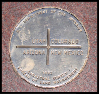
Trailblazer. Speaking of today, on today's maps you'd see we were plainly in Arizona's northeast corner at the point where you can place your right foot in New Mexico, the other in Arizona, your left hand in Utah and your right hand in Colorado.
J2020F: Not a pretty picture when viewed from the south. Where to next?
Trailblazer: We're looking for N 36° 59.938 W 109° 02.707 on my GPS locator.
J2020F: Why?
Trailblazer: We're looking for Grey Owl's geo cache and I think I just found it over there, take a look. It's right by “wolfb8's.”
J2020F: What's in it?
Trailblazer: A note from Grey Owl about The Seven Directions and links from the journal kept by the original Arizona Learning Expedition:
"After Wakan Tanka, the Great Spirit, arranged the other six directions -- East, South, West, North, Above, and Below -- one direction was still left to be placed. But since that Seventh Direction was the most powerful of all, the one containing the greatest wisdom and strength, Wakan Tanka, the Great Spirit, wished to place it somewhere where it would not easily be found. So it was finally hidden in the last place humans usually think to look -- in each person's heart.”
And a list supplied by the Arizona Expedition:
Three innovation towns: Bisbee - 85603 (in Chochise County located on the Chochise County map, Slice of Bisbee, and the Bisbee Marquee).
The second: Jerome -- 86331 (featured in Fromm's guide and Desert USA with its Jerome Chamber of Commerce listing, -- “Jerome is located in the heart of northern Arizona only 90 miles from Phoenix, 60 miles from Flagstaff, 20 miles from Sedona, 30 miles from Prescott, 20 miles from Camp Verde, 10 miles from Cottonwood and about 6 miles from Clarkdale. You can even make a day trip to the Grand Canyon from here.”
And third: Page - 86040 (home of the Lake Powell Chronicle.)
One early growth: Yuma -- 85364, 65 and 67 (where you can get the inside scoop at the Yuma Sun.)
And finally, one mid-growth: Sedona -- 86336, 39, 40, 41, 51 (Sedona Red Rock News.)
Explorer: So what's next? Where do we go from here?
Trailblazer: To the coordinates for Grey Owl's second cache: N 36° 59.614 W 109° 02.460
J2020F: Where on earth? I mean, how do we get there?
Got Knowledge?
Copyright ©2002 - 2006 Aarnaes Howard Associates. All rights reserved worldwide.
8:26 AM
Thursday, May 26, 2005

Grant, Sherman, Kit Carson and the Navajo Peach Tree Incident
Chapter Three: The Outpost
By Steve Howard, CKO
The Knowledge Labs
Table of Contents
Chapter One: Basecamp
Chapter Two: The Ridge
Chapter Three: The Outpost
Chapter Four: The Tribal Territories
“Later (Clark), as governor of the Missouri Territory - "the most powerful American in the West," as Jones puts it - he directed a series of punitive expeditions against the "Hostile Indians" who refused to submit to his authority. At the same time, Jones credits him with "struggling to find a balance between his conflicting constituencies," including "the land-hungry citizens of his territory, and the Indians he was supposed to protect."
Jonathan Kirsch
TUBA CITY, Arizona. We followed 160 to Tuba City and the Navajo National Monument instead of driving north on the 89 to Page and Lake Powell, while making our way to the northeast corner of the state. Somehow we missed Jessica Lynch and the “Extreme Makeover, Home Edition Crew” as they filmed their heart warming Season Finale in Tuba City building a Native American Veteran's Memorial Center on the Navajo Reservation.
J2020F: What did you mean back there at Chief Yellowhorse Trading Post - about the Apaches, Kit Carson and the Navajos?
Pathfinder: Arizona was not as quickly populated as the other Western territories because of fear of the Apache and Navajo.
J2020F: And, likewise Larry McMurty says his pioneer grandparents could have settled Archer City, Texas -where he grew up -- at least a decade earlier, if it had not been for the lingering fear of Comanche and Kiowa raids.
Eagle: These are the grandparents that had little use for your Missouri roots, correct?
J2020F: Good memory. Here, they had decided to seek land ownership in Texas, rather than to stay in Missouri because of the increase in outlaw activity from the likes of Jesse James, and the Daltons.
Explorer: Only to find their destination in the grips of a long guerilla war, right?
J2020F: McMurty says the fear lasted far longer than the actual end of hostilities.
Explorer: What do you mean?
J2020F: He writes: “But, while the looming war -- WWI -- may have occupied peoples' minds in other parts of the county, "(t)he war that still loomed prominently in the consciousness of frontier citizens such as my grandparents was the long guerrilla war that had been concluded, more or less, in the mid-1870s, when the power of the Comanche's and the Kiowa's were finally broken.”
Eagle: But?
J2020F: But his grandparents “like many prudent frontier citizens, lingered in safety about one hundred miles short of their eventual destination while these bloody hostilities wound down.”
Explorer: When was Archer County founded, then?
J2020F: Not until 1880. McCurty says, “It was that war that had kept Archer County largely unsettled and unsurveyed for so long, while other, safer counties were filling up. The settlers stayed back, waiting, hesitating, wondering whether the empty, farmable, homesteadable Comancheria was finally safe ...."
Trailblazer: You know what I don't get, is why they stuck around for so long? What attracted them to god-forsaken places in the first place?
J2020F: McMurty offers some clues.
Trailblazer: Like?
J2020F: Well, first of all he says, "I ... am one of the few writers who can still claim to have had prolonged and intimate contact with first-generation pioneers, men and women who came to a nearly absolute emptiness and began the filling of it themselves, setting twelve children afoot on the prairie grass, a covey of McMurtys who soon scattered like quail in the direction of the of even emptier Panhandle.”
Trailblazer: My point exactly! I still don't get why?
J2020F: Here's how he explains it: “The sense that resides in me most clearly when I think back on the twelve McMurtys (all dead now) is of the intensity and depth of their hunger for land: American land, surveyed legal acreage that would relieve them of nomadism (and of the disenfranchisement of peasant Europe) and let everybody know that they were not shiftless people.”
Explorer: And, talk about shiftless people, even Mark Twain writes how the Apaches forced the Overland Stage to abandon the southern route and delay the massive emigration to the southwest area:
"During the preceding night an ambushed savaged had sent a bullet through the pony rider's jacket, but he had ridden on, just the same, because pony riders were not allowed to stop and inquire into such things except when killed....
About two hours and a half before we arrived at Laparelle Station, the keeper in charge of it had fired four times at an Indian, but he said with an injured air that the Indian had 'skipped around so's to spile everything -- and ammunitions' blamed skurse, too.'....
The coach we were in had a neat hole through its front -- a reminiscence of its last trip through this region.
The bullet that made it wounded the driver slightly, but he did not mind it much.
He said the place to keep a man 'huffy' was down on the Southern Overland, among the Apaches, before the company moved the stage line up on the northern route."
Eagle: Kit Carson spent a twenty-five year period, beginning in 1843, as a U.S. Army officer sent to the territory -- that later becomes Arizona - for the duration of the war with Mexico, with the Confederacy, and with the Navajo.
J2020F: The U.S. military campaigns stepped up during the Mexican-American War culminating with the treaty of Guadalupe-Hidalgo in 1848, right?
Pathfinder: Right. The treaty creates the New Mexico Territories including the Arizona Territory as a part of it, carved out of Mexican Possessions. And the Gadsden Purchase in 1853 brought the rest of the Arizona and New Mexico areas under US control.
Explorer: The “Gadsden” part of Arizona had become the Confederate Territory of Arizona.
Pathfinder: And, the cash-poor Union Army chose Fort Whipple just north of Prescott as a government center because of its proximity to gold fields, while Southern sympathizers dominated Tucson.
J2020F: So that accounts for the period of time when Arizona's capital bounced back and forth between Tucson and Prescott before landing in Phoenix in 1889.
Eagle: And Fort Whipple outlasted the ”Civil-Tug-of-War.” General George Crook used the fort as his headquarters for all Indian affairs in the region.
Pathfinder: And get this. Ulysses Grant said he felt the Mexican-American War was one of the causes of the Civil War.
J2020F: How so?
Pathfinder: In his opinion, wrangling Texas away from Mexico was little more than “… a conspiracy to acquire territory out of which slave states might be formed for the American Union."
J2020F: Really? For the American Union? Wow!
Pathfinder: Civil war heroes, like Grant and others, played an important role in the taming of the southwest.
J2020F: Grant and who else?
Pathfinder: When Grant became President of the United States in 1869, William Tecumseh Sherman became the top general in the U.S. Army and served in that post until his retirement.
Trailblazer: What I remember about Sherman was one of his famous lines about his loyalty over the years that preceded Grant's election: "Grant stood by me when I was crazy, and I stood by him when he was drunk. Now we stand by each other always."
Explorer: What I remember about Sherman is that he had commanded various campaigns against the Native American tribes - to protect the Union Pacific Railroad.
J2020F: Wasn't he famous for his bloody march to Savannah?
Explorer: Yes, as in his Civil War service, Sherman sought not only to defeat the enemy's soldiers, but also to destroy the resources that allowed the enemy to sustain its warfare.
Eagle: So, as the Civil War winds down, military attention under “The Great Warrior” (as he was known to Native Americans) Sherman turned to the “Indian Issue.” In 1862 General (“Star Chief”) James Carleton declares war on the Navajos as an overreaction to events that unfolded in the two previous years.
J2020F: What?
Eagle: He had led a force, the California Column, from well - California -- to engage the Confederates, but they had long since high-tailed out of the territory to Texas. So he focused on tracking down the Mescalero Apaches and then the Navajo - at the expense of Kit (“Rope Thrower”) Carson's reputation.
Trailblazer: Carson's reputation?
Eagle: As a trusted friend he earned as a trapper and trader in the early days of his career.
Pathfinder: While related to the nomadic Apaches, the Navajo had adopted some of the Spanish ways by raising sheep and goats and cultivating grain and fruit. Some bands grew wealthy as stockmen and weavers.
J2020F: So if all the Navajo prospered as you say unlike the Apaches, why attack them? Weren't they leading the kind of life that McMurty described as the reason his family came to Texas?
Pathfinder. Not all of them. Other bands practiced a nomadic life like famous Apaches, raiding their old enemies, the Pueblos, the white settlers and even the prosperous members of their own tribe. And the military began building more forts in Navajo territory as a means for achieving their Navajo relocation strategy.
J2020F: The relocation strategy, why?
Eagle: Here's Dee Brown's take on the “Star Chief's” ambitions: “The Navajos soon learned that Star Chief Carleton had a great hunger for their land and whatever metal wealth might be hidden under it. 'A princely realm,' he called it, 'a magnificent pastoral and mineral country.' The Navajos, he said, were 'wolves that run through the mountains' and must be subdued....”
Pathfinder: In September 1862, Carleton sent out an order to spare the women and children, but to kill the men wherever they are. He wasn't interested in any talks or negotiations.
Explorer: Kit Carson is tapped by the Army to subdue the “bellicose Navajo” and remove them from their homes in Canyon de Chelly.
J2020F: Canyon de Chelly?
Eagle: In 1863 the Navajo holed up in Canyon de Chelly as they had a natural fortress that repelled attacks for years against the Spaniards and all enemies.
Explorer: In Canyon de Chelly, the Navajo in cultivated crops on the fertile floors of canyons home to the ancient Anasazi people.
Pathfinder: Rather than killing them in a military operation as Carleton wanted Carson, taking a page out of Sherman's book, chose to destroy their livestock and crops, forcing them to capitulate for fear of starving to death.
Explorer: This time, though Carson employed the mercenary Utes over several months until the Navajo were found in the canyon. That's when he destroyed 5000 peach trees - the pride of the Navajos - and most of their food supplies so that their harsh-winter food stockpile vanished.
Eagle: The Navajo never forgave Carson for what he did to their peach trees.
Pathfinder: But, after two years of investigations into the poor treatment and conditions on the Navajo reservation in 1868, and as a result of a treaty with General Sherman, the Navajos were finally allowed to return to their homes.
Explorer: Despite his harsh treatment of the warring Indian tribes, Sherman spoke out against government agents who treated the natives unfairly within the reservations system
J2020F: Speaking of which, have you zeroed in on the Grey Owl's cache location yet?
Trailblazer: Got it. Here we are, turn left.
Got Knowledge?
Copyright ©2002 - 2006 Aarnaes Howard Associates. All rights reserved worldwide.
11:42 AM
Friday, May 13, 2005

“My God, Why Would Anyone Live Out Here?”
Chapter Three: The Outpost
By Steve Howard, CKO
The Knowledge Labs
Table of Contents
Chapter One: Basecamp
Chapter Two: The Ridge
Chapter Three: The Outpost
Chapter Four: The Tribal Territories
“Lewis committed suicide a few years after the end of the expedition, and Clark struggled to turn his celebrity into cash. His dubious reward was a job as the superintendent of the Indian Office, a government agency charged with keeping the conquered nations and peoples of Native America under control and supervising their "removal" from the path of white settlement; significantly, he reported to both the secretary of State and the secretary of War.”
Jonathan Kirsch
CHIEF YELLOWHORSE TRADING POST, Arizona. Out of the Grand Canyon, we followed route 64 southeast - East Rim Drive -- which became Navahopi Rd until it intersected with 89 north into the Navajo Indian Reservation. And, then just north of Cameron we stopped at Chief Yellowhorse's roadside stand. We had been tipped off in the Grand Canyon to the quality of the Chief's son's thick sterling sliver bracelets.
Journal of 2020 Foresight: You know what it's like? It's like a meteor hit this area with such force that it made us skip a track on this adventure CD.
Eagle: Huh?
J2020F: Oh, sorry. I was on my cell phone to my wife describing my dream.
Eagle: Oh? I thought you were talking to me - those damn handless cellphone microphones!
J2020F: You know I brought along “Walter Benjamin at the Dairy Queen” by Larry McMurty. Last night when we got back to our hotel room, I fell into a dream after reading his passage about the impact that photography had on the West.
Explorer: The “noble savage image” that Mark Twain wasn't buying in “Roughing It?”
J2020F: See for yourself: "By the 1850s there were cameras everywhere, and the romantic landscapes ... gave way to photography that was almost equally romantic -- the photographers, quite naturally, gravitated to the beauty spots, to the grandeur of Yosemite, Grand Canyon, Canyon de Chelly."
Pathfinder: Like in the Grand Canyon when we visited the Kolb Studio yesterday.
Eagle: And, as in today when tourist hold their digital camera an arms length away and snap photos of themselves with the Canyon as a backdrop.
J2020F: True. However, the Kolb's arrived in the early 1900s. McMurty wrote more on the perception of the West at a tipping point in the history of the “beginning of the end” of the Wild West: "The first photographs of the Plains Indians to reach the East must have been startling to the populace because many of the Indians were so handsome, so striking.”
Explorer: Yup. If Twain saw the photos they might have chipped away at his emerging view of the West. In fact, I think it was Leonard Kriegel who wrote that Twain struggled with an "entire society created by those who had fled civilization, droves of aliens who had come to seek their fortunes on the frontier, most of who were equipped with a sense of individual destiny and little else.”
J2020F: McMurty speculates: “Seeing them in their robes of state, as it were -- the very personification of the noble savage -- must have awakened at least a little ambivalence in the viewers, for the pictures themselves contradicted some of the most wildly propagandistic aspects of the rhetoric of conquest."
Eagle: And talking about “rhetoric of conquest,” in the mid-1800s, according to Dee Brown, the Indian Wars got ugly by the 1860s. Events set in motion when the war with Mexico ended and the '49ers discovered gold in California came to a head.
J2020F: The US government stepped up coordinated military campaigns against the western tribes who resisted, as had the all of the eastern tribes, right?
Explorer: Even though Twain was one himself he became repulsed by the fortune-seeking easterners crossing by the thousands on the emigrant trails through Indian Territory.
Eagle: Brown wrote: “Indians who lived or hunted along the Santa Fe and Oregon trails had grown accustomed to seeing an occasional wagon train licensed for traders, trappers, or missionaries. Now suddenly the trails were filled with wagons, and the wagons were filled with white people."
Explorer: Kriegel on Twain, "His disgust with the swaggering desperado, his annoyance with those who romanticize the Indian as 'the Nobel Red Man,' his fear of lynch law, his admiration for bankers, merchants, and honest miners -- all of these represent the civilized point of view."
Trailblazer: Wow, and here I thought your dream was about the Grand Canyon.
Pathfinder: I thought you were talking about the scenery we've been viewing for hours as we left the Grand Canyon for Indian Country - inhabited by the eight tribes and five reservations.
Eagle: Those would be the Havasupai, Hopi, Hualapai, Kaibab Paiute, and the Navajo on reservations surrounding the park.
Pathfinder: I've read somewhere that in Arizona alone there are 20 reservations covering 25% of the land.
Eagle: Right, and those tribes in Arizona belong to three linguistic families: the Athabascan, including the Apache and Navajo; the Uto-Aztecan, to which the Hopi belong as well as the Kaibab Paiute, Papago, Pima and Yaqui; and the Yuman, including the Chemehuevi, Cocopah, Havasupai, Hualapia, Mohave, Yavapai and Yuma.
Trailblazer: One of the interesting things about this “Four Corners Region” is that while Native American people were present in the region about 12,000 years ago, little remains to describe what they experienced, how they lived, what had happened to them.
Eagle: I think there's an historical gap of about 8,000 years. Apparently we know that the Hohokam and Hisatsinom tribes flourished here when they built elaborate irrigation systems and cliff dwellings until the mid-1400s when two centuries of drought and nomadic tribe invasions terminated their cultures.
Pathfinder: Isn't there some speculation that the may have been absorbed by the nomadic Apache and Navajo tribes?
Eagle: Yes, as I understand it. Likewise, the Paiutes moved into the region once occupied by the ancient Anasazi and Fremont cultures.
Pathfinder: And the Hopi, descended from the prehistoric Pueblo people. Today, they follow the ancient traditions as dry farmers growing corn on plots at the base of mesas.
J2020F: So, we have a gap between the early ancestors and roughly the late 1400s or early 1500s when the Spanish explorers and Jesuits tried to colonize the area, right?
Explorer: From a European perspective, certainly.
J2020F: Franciscan Friar, Marcos de Niza, followed by Francisco Vasquez de Coronado first came looking for trade routes to the orient and Seven Cities of Gold, as well as to colonize the New World in 1539.
Eagle: In 1680 however, the Hopi revolted killing the priests and burning the missions during what became known as the Pueblo Revolt.
Pathfinder: Shortly thereafter, Jesuit Eusebio Francisco Kino began the first successful mission work in Pimeria Alta (presently southern Arizona) with the founding of several missions, including the presidio and mission at Tubac as well as the still active San Xavier del Bac
Trailblazer: But, the Hopi Pueblo Revolt continued for two centuries. The Apache and Navajo joined in with their resistance to the Europeans and later to the Mexicans when they asserted their sovereignty.
J2020F: After leaving the Grand Canyon on 64 it became clear that the Navajos occupy by far the largest reservation --16 million acres just east of the Grand Canyon
Eagle: The Navajos are also the largest of any other North American tribe and for this part of our trip served as a portal into “Indian Country.”
Pathfinder: If you had a copy of the Santa Fe Trail map, that served as the main artery opening up the “Southwest Frontier between 1800 to 1850” for “white Americans” you'd see we were in the “open territory” well to the west of Santa Fe, Taos and Albuquerque (the Rio Grande) between the Colorado River to the north and the Gila River to the south.
Trailblazer: Novelist Tony Hillerman loves to roam this area -- known to the early emigrants from the east as the Great American Desert -- for a source of inspiration. He travels “the vast empty space, Indian reservations, mountain ranges, nameless canyons, old volcanoes and rough country where it is easy to get lost.”
Explorer: Nowadays, the AAA calls its map of this area in the Southwest simply “Indian Country.” Four states - Arizona, New Mexico, Colorado and Utah -- later carved out of the territory sit in the middle of Indian Country. On the eastern border you find Sandia Mountains in New Mexico.
Eagle: On the opposite border to the west is Nevada from where we came. In the extreme upper left from Utah's Indian Peak Range down to the extreme bottom left we find Arizona's Bozarth Mesa.
Explorer: And from Colorado's Bear Peak in the upper right it runs down to the bottom right to New Mexico's Rattlesnake Hill.
J2020F: The scenic route we took from our Grand Canyon hotel retraced our east rim tour past the Desert Watch Tower and onto the vast expanse of Navajo and then, finally Hopi reservations.
Pathfinder: Talking about life zones, we passed from Eastern Sierra-like pine trees, like the ones we were used to viewing on the trip here from Mammoth, hiding the view of the Canyon to lower elevation and flatter, rolling hills of the reservation land.
Trailblazer: We followed 64 to Cameron and picked up the 89 which boaters take past Page in route to Lake Powell. We took to 160 instead past Tuba City and the Navajo National Monument.
J2020F: After miles of passing roadside trading post stands offering authentic Indian jewelry artwork, we pulled off -- at one of the two Chief Yellowhorse venues.
Explorer: Pulling off, gave us the opportunity to photograph a lower fork of the Colorado River that had carved lesser, but more spectacular gorges.
Trailblazer: But, between the Canyon and the Mesa country the landscape turned almost lunar from ancient volcanoes. We all marveled at how tough it must be to scratch out a living.
J2020F: That is unless you happen to be a Native American, an anthropologist, archeologist, a geologist or a novelist like Tony Hillerman.
Trailblazer: Let's see, what else is on his list of attractions? In addition to the Grand Canyon - “Valle Grande in the Jemez Mountains, the world's largest caldera (collapsed volcano) valley; endless magnets for anthropologists: the Mesa Verde cliff dwellings, the mysterious Chaco Canyon structures and countless others; the entire Navajo Nation; a long list of lively Pueblo reservations; and too many national parks and monuments to mention….”
Explorer: If we had more time, you'd probably want to discover El Malpais, for example, a sea of ancient black magma - the lava stream from Mt. Taylor.
Pathfinder: He would definitely. For me, I'm reminded that this is the same general area where Cochise and his Apaches came through. Where Geronimo roamed. Where the Civil War played out after the Mexican American War and where Kit Carson called home - to the dismay of the Navajos.
J2020F: Why do you say that?
Got Knowledge?
Copyright ©2002 - 2006 Aarnaes Howard Associates. All rights reserved worldwide.
5:51 PM
Monday, May 02, 2005

Grand Canyon Expeditions, Life Zones, Tribes, and the Watch Tower
Chapter Three: The Outpost
By Steve Howard, CKO
The Knowledge Labs
Table of Contents
Chapter One: Basecamp
Chapter Two: The Ridge
Chapter Three: The Outpost
Chapter Four: The Tribal Territories
“Clark first met Meriwether Lewis when they were both serving in the long war that was waged against the Native Americans, an encounter that prefigured their famous expedition. Jones invites us to see the Voyage of Discovery on which they embarked at the invitation of Jefferson in 1804 as an expression of Jefferson's geopolitical ambitions - a water route "from sea to sea" would allow the United States to dominate the continent of North America to the exclusion of Britain, France and Spain.”
Jonathan Kirsch
GRAND CANYON, Arizona. We just weren't prepared for the magnificence of the Grand Canyon sunsets, sunrises, and afternoon storms. Leaving Laughlin for Arizona brought no tears or time-extension wishes. All four of us rendezvoused in the hotel's coffee shop at 6:30 a.m. before loading our SUV, crossing over the Colorado River, and getting a jump on our trip through the first of several Arizona counties - Mohave.
Journal of 2020 Foresight: Let's synchronize our plans. Our original itinerary, to loosely trace the major mountain man trails of the westward expansion, yet in reverse, took us out of the Sierras as we followed the Great Basin Trails in California and Nevada. After two unexpected stops in the greater Oakhurst - Yosemite and greater Mono Lake - Mammoth areas on 395, we traveled south and west of Death Valley before turning east towards Laughlin.
Eagle: Here's were we picked up US 95 and took the tour through Needles, where Jedediah Smith crossed the Colorado River in 1826, (intersected famous Route 66 - backdrop for the excellent adventures of Tod and Buzz in the '60s) and then we took 163 to Laughlin. I say we start here out of Laughlin and take I-40 via 68 out of Nevada and into Arizona.
Explorer: I vote not to stay in Williams as AAA recommended. I can't see staying there only for the train trip to and from the Canyon with a bus tour around the rim thrown in.
Trailblazer: I'm with you. In fact, I anticipated that we might change our plans, so last night I “googled” the area in and around the park and found lodging at the Best Western a few miles outside the park. But, it's the only one without a pool.
Pathfinder: Great. I can live without a pool.
J2020F: Me too. What do we have to look forward to once we get there?
Pathfinder: The National Park Service's official map and guide describes the landscape as so uniquethat it startles you for the first time. It is so vast that it is hard to comprehend.
Eagle: So vast? How vast is it? (Rim shot, please).
Pathfinder: I'll give you a rim shot. “As the crow flies 10 miles separates the southern and northern rims, yet as the car drives the trip stacks up to 215 miles. The canyon itself is 277 miles long, 5,700 feet deep at the North Rim, which draws about 10% of the park's visitors. The heavily visited South Rim averages about 1200 feet lower than the north.”
Explorer: Aren't we fairly near Painted Desert?
Pathfinder: What, are you reading over my soldier, now? “It says nearby the multicolored walls to the east, lies the Painted Desert.”
Eagle: And, isn't there a local reservation somewhere near there? This region's environment and climate differs from the one supporting the Great Basin tribes -- like the Paiute(originators of the Ghost Dance spread, first by Wodziwob and later by Wovoka and later triggered Sitting Bull's death), Shoshone(famous in U.S. history as the tribe of Sacagaweawho guided both the Lewis and Clark and Manuel Lisa expeditions and ended up on the silver dollar), Ute and Washoe.
Pathfinder. Right. The brochure says that the western canyon border including Havasu Canyon is part of the Havasupai Reservation - “… an agriculture tribe that preceded the first European explorers arriving in 1540. About 250 tribal members still live in the canyon today.”
Trailblazer: I remember seeing something about them recently.
J2020F: Ah, the driver speaks.
Eagle: Almost. Similar sounding name to us, Hualapai. What you heard is actually a complex and interesting situation. Basically, The 1,500-member tribe shares a 108-mile border with the national park. However, their sovereignty “… allows it to use its 1-million-acre reservation in ways the federal government forbids elsewhere in the Grand Canyon.”
Explorer: I kinda remember something controversial about Evel Kneivel and the Hualapais a few years ago.
Eagle: No, it was his son Robbie who jumped the canyon on their land. Lately the tribe plans to complete a 130-foot horseshoe-shaped glass skywalk to Grand Canyon's dismay.
Trailblazer: A what?
Eagle: The idea is tourists would be able to hang out over the rim and experience the view through the glass floor 3000 feet down to the Colorado River.
J2020F: I've head rumors that these plans are just the beginning. Their critics say the tribe wants to turn the natural wonder into an amusement park - and they're making it fast and easy for Las Vegas tourists to visit and return to the sin city.
Eagle: Well, however it shakes out, I still feel that standing here on the on the rim is an experience to humble the soul.
Pathfinder: I know what you mean. Look around and it's not hard to view five life zones in the Northern Hemisphere, right here in one place. While you can search the four corners of the world, you won't find any other place that vividly lays out such a vast expanse of time before your very eyes.
J2020F: It is truly breath taking when you reflect on just the layers of rocks demarking the Earth's history dating as far back as 2 billion years ago and to a more recent era nearly 250 million years ago.
Pathfinder: Closer in time to our lifetimes, yet nearly 500 years ago, the first European explorers, Francisco Vasquez de Coronado's expedition (Garcia Lopez de Cardenas) recorded sighting the Grand Canyon in 1540 as they searched for the Seven Cities of Gold.
Explorer: Slightly over a hundred years ago, Major John Wesley Powell led the first scientific expedition centuries after Coronado to map the entire length of the canyon. With 9 expedition members he left a town called Green River, Wyoming in the spring of 1898. Six of them made it to the Grand Wash Cliffs on August 30th.
J2020F: For me, I have to say that the canyon tourist area had changed beyond recognition -- not having been here for a number of years.
Trailblazer: What do you mean?
J2020F: I only remember a major lodge and an area where Native Americans danced at different times. And gazing out into the canyon, I have to admit the view looks so magnificent, it seems almost artificial, like some grand Hollywood backdrop.
Explorer: Unnatural? Well the dangers are real enough. We parked our vehicle and hiked and viewed, and hiked and viewed down into the great abyss.
Trailblazer: I'll say. It's a two hour trip down to the floor of the canyon and more than four hours back up to the top. Signs caution not to hike after early morning or late afternoon -- not so much a danger to physical conditions as much as electrolyte level.
Pathfinder: Look at this. At the Bright Angel trail head an open letter from someone in his early 20s recounting how he and a cousin had to be rescued because they misjudged the situation when low on water and food.
Trailblazer: Tourists! Visitors also aren't tuned into the shifting weather patterns. Afternoon rain showers frequent the canyon's summer season at both rims.
Temperatures range 30 degrees from 50 degrees F to 80's degrees F. In the winter, the temperature drops for 30 degrees F to 0 degrees F and heavy snowfalls can close the Northern Rim.
Pathfinder: So, to prevent accidents you are cautioned to stay on trails away from the cliff edges and away from the rims during lightning storms. Even day hikes take you into a world where preparation, self-reliance, and common sense count.
J2020F: Rangers and posted signs remind you that it is illegal to feed deer, squirrels or any other wild animals in the park. Visitors have been kicked, chased and bitten while trying to feed wildlife.
Trailblazer: The climate is extremely dry year-round; you need a minimum of one gallon of water or fluids in the summer for every 8 hours of hiking. High carbohydrates, snacks of grains, crackers, fruits, non-fat energy bars should be eaten every 20 - 30 minutes. Heat exhaustion - 20 case a day -- due to intense dehydration - show symptoms of a pale face, nausea, cool and moist skin, headaches, and cramps.
J2020F: So, you need to bring water, eat high-energy foods, rest in the shade, and cool the body.
Trailblazer: Because, if you really overdue it you can become a victim of heat stroke -- flushed face, dry skin, weak and rapid pulse, high body temperature, poor judgment or inability to cope, unconsciousness.
J2020F: I guess that's the other thing. You can read how the canyon floor is typically 20 degrees hotter than at the rim. It's almost counterintuitive as we peered down under the heat of the summer sun into the shadows and cool green terrain --and river.
Explorer: Check this out. Kolb's studio. Here's what we saw in the IMAX presentation a block from our hotel room. The Kolb brothers explored the Canyon like so many other Native Americans, Spanish conquistadors, mountain men before them.
Pathfinder: The Kolbs took a 1200-mile trek down the Colorado to Needles, California and dedicated a major portion of their lives to photographing the Canyon.
Eagle: The movie speculated about "the Ancient Ones" who probably lived in the canyon and did a decent job reconstructing later “expeditions into the unknown.”
J2020F: Especially telling the story of Powell's scientific expedition. How the team met unbelievable rapids and challenges one after another, not knowing what to expect around the next bend.
Trailblazer: What a major irony. After being thrashed about, boats damaged, supplies lost and one expedition member killed, a small party decided they had enough and took off on foot to hike out of the Canyon, believing it was far safer to do so, than to continue the dangerous adventure.
Explorer: They were never heard from again. They totally disappeared. And, ironically within in a short time the rest of the boats and crew engaged some of the calmest parts of the Colorado River.
J2020F: The one thing I do remember that hasn't changed - and was a tip we heard from almost everyone else who had visited the Canyon - make sure you view the Canyon in late afternoon and early evening to behold the contrasts and vivid colors.
Explorer: I'm glad we did on our way towards the east rim, stopping every so often at a lookout.
Pathfinder: I'm glad we struck up a conversation with that woman who said we needed to visit the Watchtower at the Desert Viewpoint for twilight - her party had entered from the east and said it had been spectacular.
Trailblazer. Me too. Especially when those first rain drops bounced off our heads. Large individual raindrops spit at us for a short time as a storm blew into the canyon with a mist that curtained the sun. Thunder echoed off in a distance.
Explorer: Don't forget those bolts of lightning accelerating to the surrounding ground even though someone told us they were miles away. Running to The Tower's shelter made me feel better.
Eagle: And, it gave us a chance to appreciate the fact that the tower had been painstakingly built to honor Native Americans.
J2020F: I agree. Up the spiral staircase along the rock walls and on each floor a Hopi artist had painted stories and images. As darkness began to encircle us and the storm grew closer, so we hopped in our SUV to return to the hotel. And, once on our way, we sited our first wildlife of the trip. Two bucks with velvet antlers. The only wildlife we saw before leaving the next morning.
Got Knowledge?
Copyright ©2002 - 2006 Aarnaes Howard Associates. All rights reserved
7:06 AM
|
|
| |
|
|
|
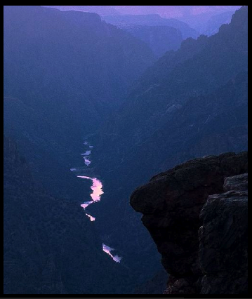

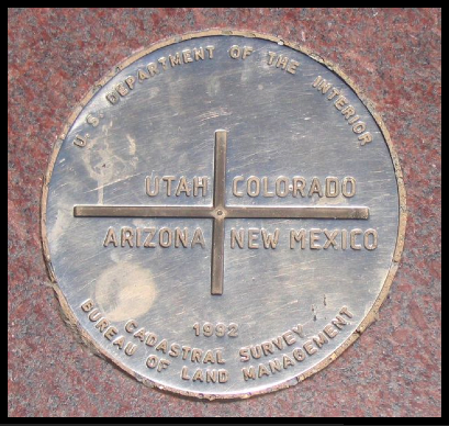
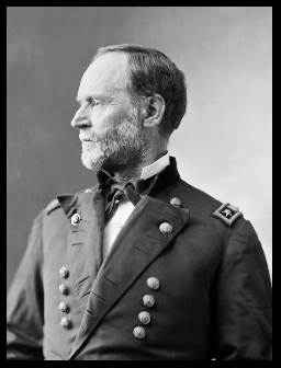
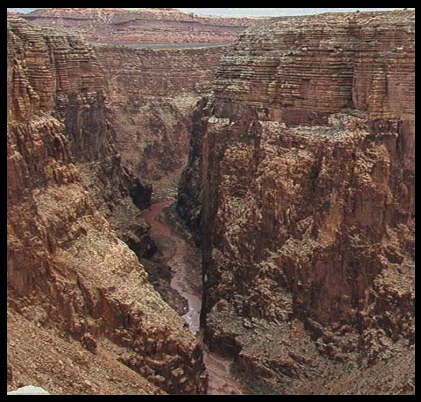
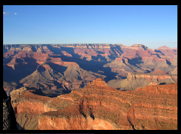